
Hammock Camping on Minnesota’s Superior Hiking Trail

Hello friends,
In my last post, I was putzing around on my bicycle and I shared a video I made for my Japan presentation. Well, a lot has happened since then. I went to the May Day Parade for the first time and enjoyed it immensely. If you happen to be in Minneapolis during the first weekend in May, you’ve gotta see May Day!

After the parade, there is a play run by volunteers, which revolves around the theme of rebirth. This year’s story was based on #BlackLivesMatter.
As for after May Day, the following weekend opened up for me. At first I thought I could get a lot done, mostly pertaining to laundry, prep for MSP Comic Con (which is this weekend! Come see me and my bro!), and a list of other things. But, then I thought about the last time I had gone camping, which had been ages ago (last Fall in the BWCA). It was a no-brainer, without hesitation, I headed north to Minnesota’s Superior Hiking Trail (SHT).

This is a trail marker. You can find them all along the SHT. They help guide you through the rugged terrain.
Hammock Camping on the SHT
So why hammock camping? Well, I work at an outdoor store and I’ve heard a lot of my coworkers rave about hammock camping. I was skeptical, since I have been using a tent for a long time, but I was also intrigued. Luckily, one of my coworkers let me use his whole ENO (Eagle Nest Outfitters) hammock set. This included the hammock, an underbelly to stow your gear, a bug net, and a rainfly tarp. I didn’t weigh it, but I would say it is pretty comparable to the weight/size of a 2-person tent.
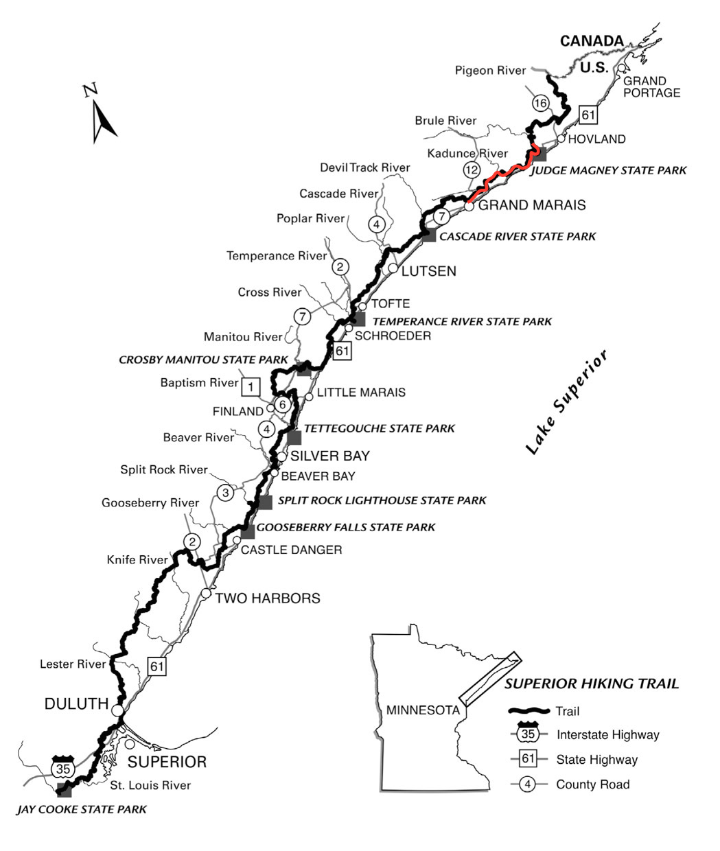
Now, for my planning. I didn’t plan too far ahead. What’s nice about the SHT is that you don’t need to. Thanks to the Superior Hiking Trail Association (SHTA) and the Superior National Forest, the 296-mile long trail hosts 96 backcountry campsites and dozens of easily accessible trailheads for no cost at all (no permits either!). So, the next time you have some money or time to donate, consider helping out the SHTA. They are the reason this awesome trail exists.
In total, I hiked 26.6 miles in 3 days.
The only thing I did plan is where I’d be starting and finishing and how I’d get there. I decided to start at Judge Magney State Park, which is famous for it’s mysterious Devil’s Kettle Falls, and then walk for 3-4 days south to Pincushion Mountain (just outside of Grand Marais). Something most backpackers do is park their car at a trailhead and then they get a ride to the other trailhead. They then hike back to their car. This is what I did, so I parked my car at Pincushion and then asked Harriet Quarles Transportation to give me a ride to Judge Magney. For one person, it cost $47, but it gets less expensive the more people you have in the car. There are other transportation services too.

Judge Magney’s Devil’s Kettle Falls. It’s famous for being split in half. One half flows over the rock face, the other half falls into the rock face. No one knows where the water escapes to.
Day 1: Judge Magney State Park (plus 2-mile hike in and out to Devil’s Kettle) to South Little Brule River campsite. (~5 miles)
My first day was a long one. After the 4 hour drive, plus the transportation to Judge Magney, I was tired mentally, but not physically. When my driver dropped me off, I put on my pack and started my hike to Devil’s Kettle Falls. Though the trail was well marked, it was pretty rugged. Probably due to the recent rainfall, the trail was muddy and hard to climb at times (especially with a pack on your back!). It was all worth it though after getting to the falls. I’m happy to say that I’ve witnessed the mysterious flow of the Devil’s Kettle.
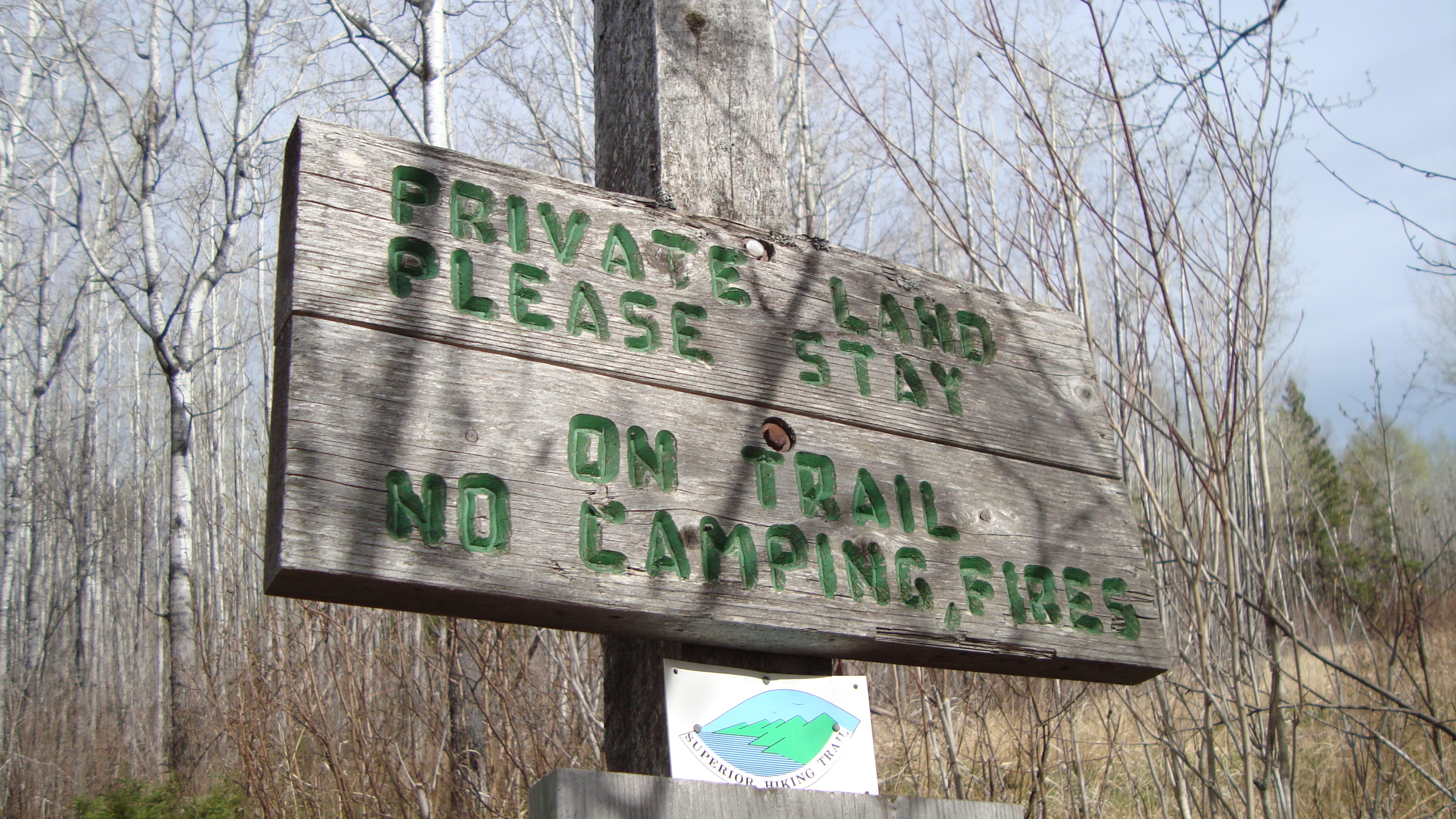 I climbed back down and followed the signs for the SHT. They are easy to follow, since they often have arrows pointing you in the right direction, as well as there are blue markers in the trees to help guide you. To be honest, the next 3-miles I hiked from Judge Magney to Little Brule River weren’t too exciting. It was a lot of private land, so there was some logged areas and wet fields to trudge through (there are lots of boardwalks, thanks to the SHTA). I did see a Pileated Woodpecker though!
Once I got to the Little Brule River, the trail became much more interesting. I climbed up rugged and rocky ridge lines and followed the river for a quarter mile to my campsite. It was the perfect time of day to soak up the Superior National Forest’s beauty. The sunlight hit upon the trees just right, giving everything a soft look.
 I set up camp at the South Little Brule River Campsite. It had everything you could ask for: a fire pit, makeshift wooden benches, a trail to my water source, and a view of the river. It also had 2 very sturdy trees, perfect for a hammock to fit between. Sadly, the wood was too wet to make a fire. Overall, my first day on the trail was a success!
 Day 2: South Little Brule River Campground to Kimball River Campground (~6-7 miles)
For my first night sleep in a hammock, I slept pretty well. It had been awhile since I’d slept in the woods and the sounds of the forest kept me up for a short while, but I was quickly lulled to sleep by the sounds of the Little Brule River. When I awoke, I felt so comfy warm in my sleeping bag. I spent at least 20 minutes relaxing in the hammock, letting the morning light shine upon my face. After packing up all my gear, I made myself a peanut butter bagel sandwich. I also boiled a liter of water from the river, so to have water for the day. I soon said goodbye to my campsite and started to walk south, following the blue markers in the trees.
Something I genuinely enjoy is walking silently in the woods. Not only is it prime time to see some wildlife (and birds!), but it is also a time for me to reflect. Or sometimes I honestly don’t think at all; I just walk. I didn’t see anyone on the trail that day. It was just me, a ruffed grouse, and a mixed forest of spruce and cedar.
 There was a 1.5 mile section of the trail that bordered Lake Superior. It was nice for the first half mile, but walking on pebbly sand became a bit tedious (especially with chaco sandals!)
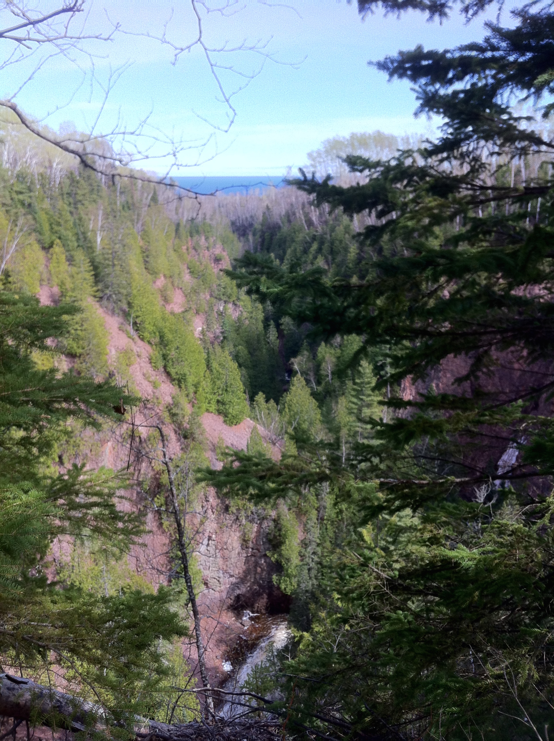
Today’s trail section was much more geologically interesting. I passed through a few quiet creeks, climbed ridge line shrouded in conifers and birch, and delved deep into two river gorges: the Kadunce River gorge and the Kimball River gorge. I decided to camp at Kimball and was pleasantly surprised to find a tent already set-up. It was empty, but it meant that I’d have company for my second night on the SHT!

The steep decline down into Kimball River gorge. The campsite was at the bottom.
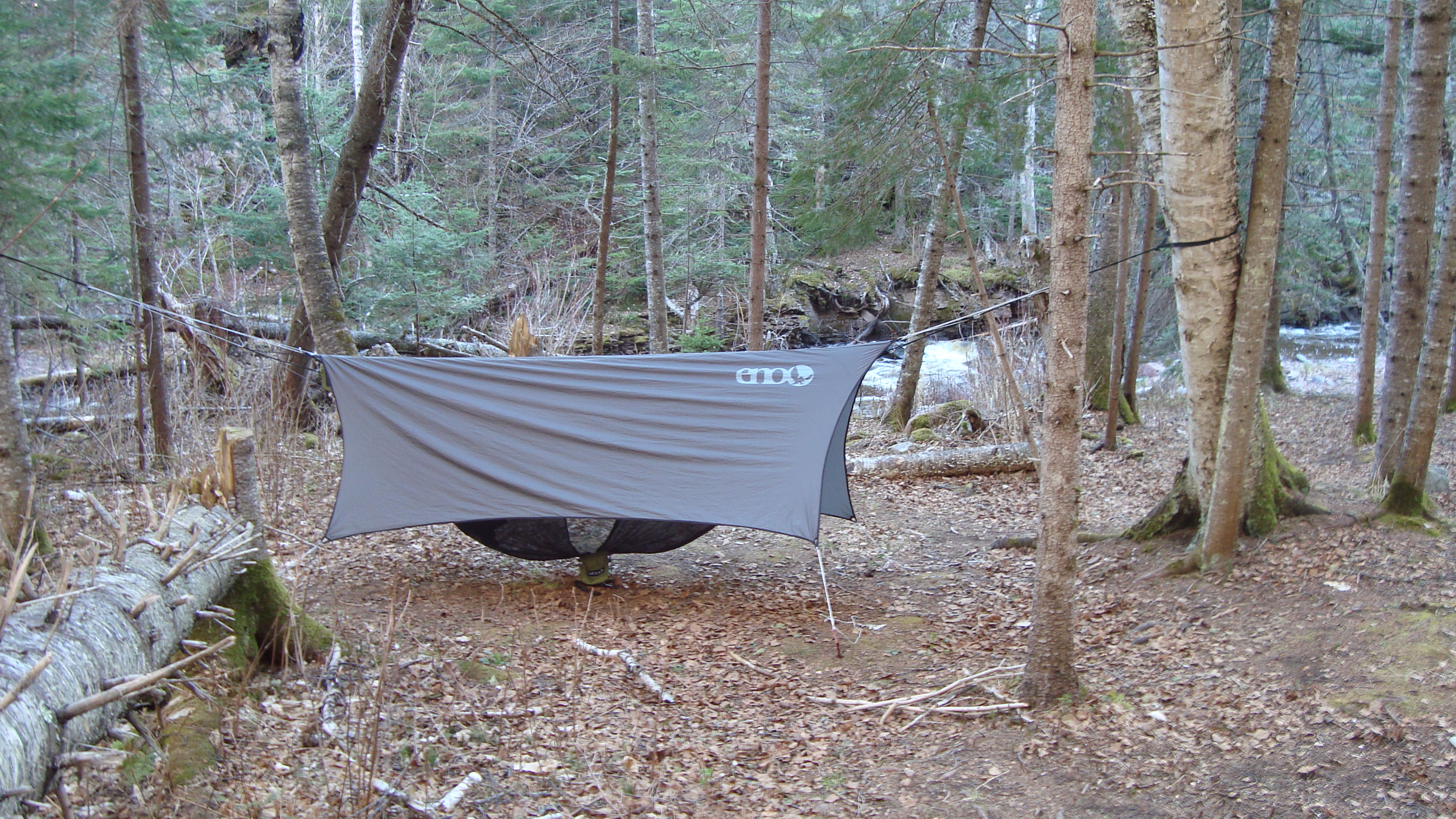
What a view I had on my second night hammock camping!
Before meeting my campmates, I spent at least 45 minutes setting up my hammock. If you’re a pro, I’m sure it would take only 10-15 minutes, but since it was my second time putting everything together, I made sure to be meticulous with my knot tying and tautness. Now, that’s something to know about hammocks, understand that if you have the whole set up, you have a bunch of knots to tie, all of which must be taught and even. The hammock and underbelly are a breeze to set-up, but the rainfly and bug net are a bit tricky. I promise you though, once you get the hang of it, hammock camping is bomb. I slept much sounder and it was nice not having to worry about wet gear, since all of it (except for my food) was in the underbelly, hanging above the wet earth. (I didn’t bring a bear barrel or bear bag, so I usually double/triple bag my food into plastic bags and a water proof bag. I then chuck it into the woods, far from camp, so if a bear were to come, he/she wouldn’t come near the campsite).
The rest of the evening went swimmingly. I boiled some water for drinking, as well as for making my first dehydrated meal. I started with Backcountry Pantry’s Organic Sicilian Lasagna. I cooked it in my MSR reactor stove and was pretty impressed. It tasted real good and it even had a kick to it! There’s nothing better than having a warm meal after a long day of hiking.
It was when I was writing in my journal that I heard voices coming from up trail. Within moments, a friendly gentlemen with fishing gear appeared and we exchanged hellos. His name was Jeremiah and he told me that him and his friend had spent the whole day fishing different rivers and that they were pooped. I offered to help gather firewood if they wanted a fire, and we both decided that a fire is a must! In no time, firewood was collected and Jeremiah got the fire going. His friend Joel eventually appeared with a very sweet puppy too.
I was happy to share a fire with these gentlemen. They told me all about fishing and what to look for while hiking on trail. They also shared some scary stories about the BWCA and a nearby wolf pack that lives up the Kimball River. The best part though was sipping a Bent Paddle IPA (brought by Jeremiah) while looking up at the crystal clear stars above. Thanks to the fire and good company, I didn’t feel cold at all.
 Day 3: Kimball River Campground to Pincushion Mountain parking lot ( ~13 miles)
I woke up the next morning feeling refreshed. The sun was out and I could see blue skies. I spent a majority of my morning putting away my hammock and packing up my things. Jeremiah and Joel said their goodbyes just as I was eating breakfast. They told me they had more fish to catch at the Devil’s Track! When I left the campground, in my mind, I was expecting to walk around 9-10 miles that day. Little did I know that a bad storm was coming and that I’d be hiking all the way to Pincushion!
I couldn’t of asked for a better day to hike though. When I hiked out of the Kimball gorge, I ended up hiking along a rocky ridge line. Through the birch trees (dotted with bright green due to the baby leaves), cedar, and spruce, I could see glints of Lake Superior. I was deep in the Superior National Forest and I could tell that the trees that I hiked beneath were very old. I had to evade their uprooted roots and low hanging branches, heavy with conifer leaves. It was still a bit dewey too, so the smells of pine and humus were strong. I love those smells.
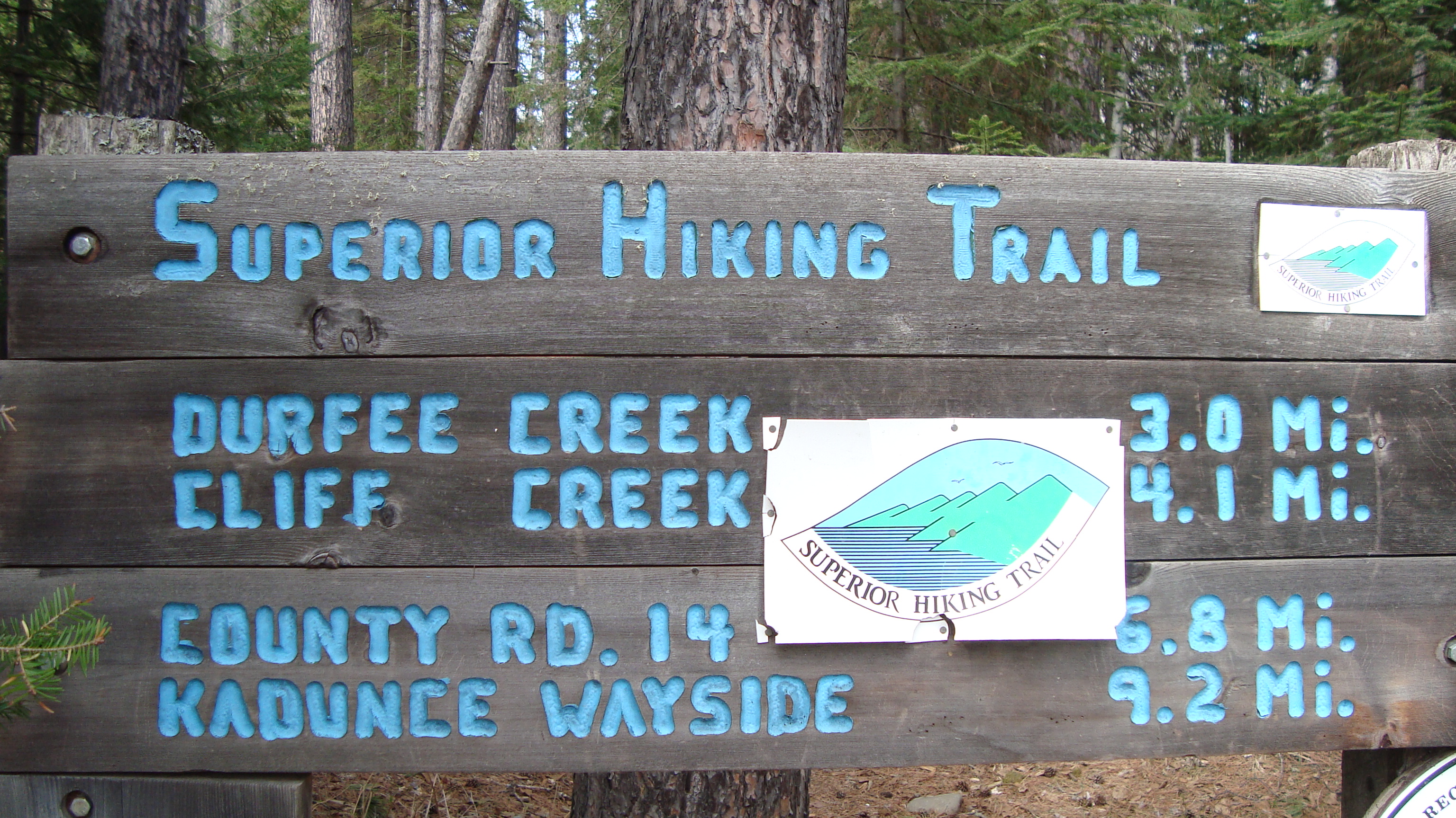
This is a SHT sign from Lindskog Road, looking north.
The third day was definitely the most scenic day. It was also the most strenuous day too. I hiked in and out of 3 creeks and 1 canyon, each of which got more deeper as I went along. Cliff and Durfee creek offered quiet escapes, shaded by the nearby conifer trees. Between each creek were stunning views of of Lake Superior. After Durfee Creek, I climbed higher and higher until I reached the top of a prairie called Wildflower Hill. From there, I popped-a-squat and embraced one of the best views of Lake Superior.
As the story goes, once you reach the highest point, you must go down again. So, I reached Woods Creek and started a slow descent to the bottom of the gorge. It was a beautiful walk. I took a lunch break at the Woods Creek Campground and made my final dehydrated meal of Chicken and Dumplings. I decided to eat half of it and put the other half into my Hydroflask thermos to save for later (I was thankful I did that near mile 11!). It was here that I had phone connection and looked up the weather report. It told me there was a high chance of rain and heavy wind. It was disconcerting. I decided to hike till Devil’s Track Campground and to decide from there if I wanted to spend the night or not.
The Devil’s Track. A view near the top.
The most beautiful and most difficult hike of the whole trip was my time on the Devil’s Track River. Compared to the other river’s I hiked beside, this took the cake (and then some). From Lindskog Road, you enter the Devil’s Track Canyon. For at least 2-3 miles, you climb up the steep Devil’s Track River Gorge until you reach the canyon’s edge. Near the top, there is an amazing view of the canyon and Lake Superior. (The above picture didn’t do it justice.) By this time, my legs were really sore, mostly my calves. They had not been ready for so many climbs in one day, but I knew I had to press on; the storm was coming and I had to decide quickly if I wanted to brave it or hike the extra 3 miles out to Pincushion.

Near the top of the south staircase from Devil’s Track bridge
Once I reached the Devil’s Track Campground, I pulled out my phone and checked the weather again. It showed even worse winds and rains than before. I decided then and there to hike as quickly as possible to the parking lot. I gobbled down the rest of my Chicken and Dumplings and prepared for the steepest climb of the day: hiking out of the Devil’s Track.
It was a constant uphill climb till Pincushion Mountain’s parking lot, but within 2 hours, I had made it. I was a bit sad that I had to cut my trip short. I had been looking forward to camping overnight in the Devil’s Track canyon and then sauntering out, but I guess there is always next time. While driving back to Minneapolis, I was very glad I decided to leave early. The storm was very bad. Heavy rain and winds even made driving home treacherous. As I drove south, I thought what it would’ve been like to hammock camp in such a heavy storm. A part of me was intrigued and wanted to brave the elements, but most of me was grateful to have the car to shield me from the wind and a bed to look forward to for the coming evening.
Thanks for reading. <3
Much love,
-Molly
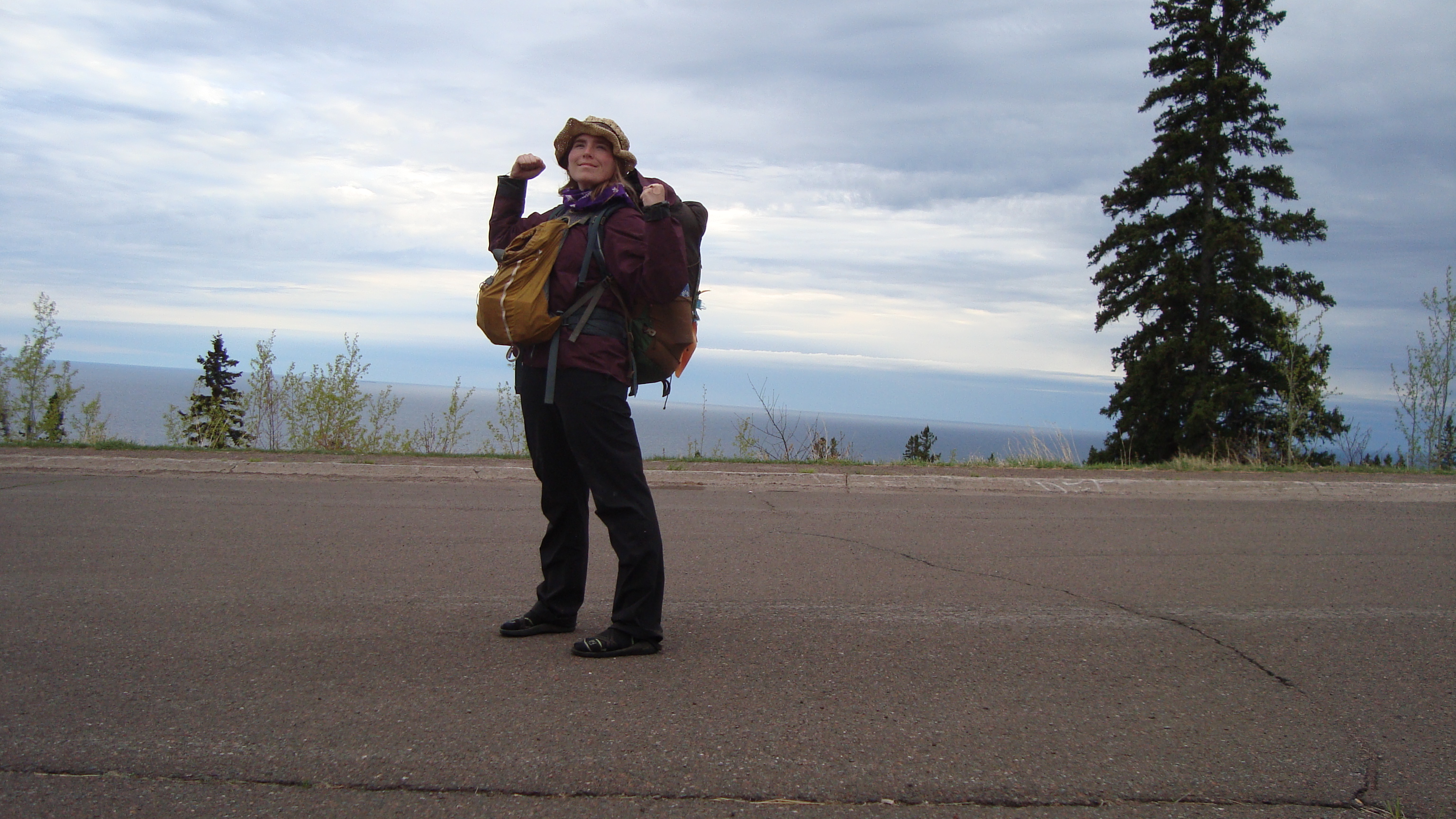
I made it. I beat the storm!


Love this post! A great adventure! 😊
Sent from my iPad
>
LikeLike
Pingback: Remembering Paul: A Reflection on Depression and Mental Illness | Molly's Journey to the West
Pingback: Hiking the Superior Hiking Trail and Camping in Gooseberry Falls State Park | Molly's Journey to the West
Pingback: Madeline Island: Ferry Rides, Fall Colors, and Big Bay State Park | Molly's Journey to the West
Well written and good pics. Sounds like a nice adventure.
LikeLike
Pingback: A 2020 and 2021 Review and Check Out The Coco Canary Newsletter To Keep Up With What I am Up To | Molly's Journey to the West